Land For Sale, Kidderminster, Worcestershire
 4 photos
Property ID: 157319
£225,000 Freehold
Land West Of Kinver Lane, Kidderminster, Worcestershire, DY11 5YD
Type
Land
Status
Available
Size
12.55 Acres
Key Features
- Approximately 12.55 acres
- Attractive rural village setting close to Kidderminster
- For Sale by Private Treaty. Unconditional offers are invited
Skip the agent. Advertise it on
Boxpod for £12/m Find out more

Description
Caunsall is a village situated within the Wyre Forest District of Worcestershire, approximately four miles north of the market
town of Kidderminster. Predominantly residential in nature, the village is set within the surrounding Worcestershire countryside. Kinver lies just two miles away and is a charming village known for its scenic surroundings, including Kinver Edge and the National Trust rock houses. Approximately four miles away, Kidderminster provides a broader selection of amenities, such as supermarkets, retail outlets, and railway services, with frequent links to Birmingham.
The village is particularly well placed for easy access to motorway and other transport links, in particular the A449 and
M5 motorway.
Approximately 12.55 Acres
Attractive Rural Village Setting Close To Kidderminster
For Sale By Private Treaty. Unconditional Offers Are Invited
Location
Caunsall Is A Village Situated Within The Wyre Forest District Of Worcestershire, Approximately Four Miles North Of The Market
Town Of Kidderminster. Predominantly Residential In Nature, The Village Is Set Within The Surrounding Worcestershire Countryside. Kinver Lies Just Two Miles Away And Is A Charming Village Known For Its Scenic Surroundings, Including Kinver Edge And The National Trust Rock Houses. Approximately Four Miles Away, Kidderminster Provides A Broader Selection Of Amenities, Such As Supermarkets, Retail Outlets, And Railway Services, With Frequent Links To Birmingham.
The Village Is Particularly Well Placed For Easy Access To Motorway And Other Transport Links, In Particular The A449 And
M5 Motorway.
Description
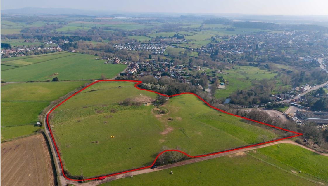
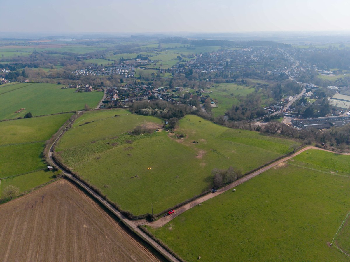
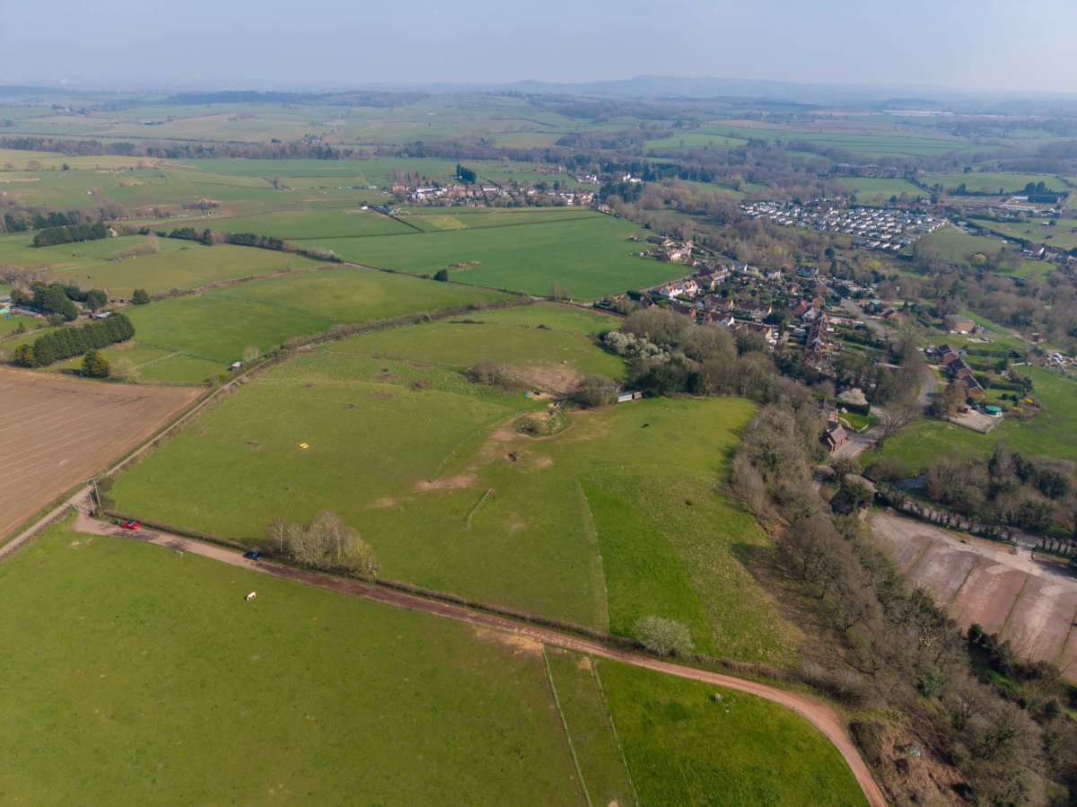
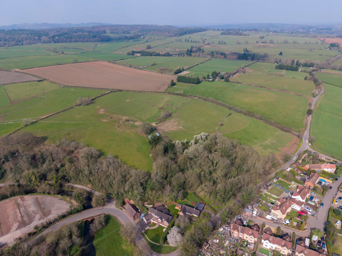
The Site Comprises Grass Land, Currently Used For Grazing And Extends To Approximately 12.55 Acres (5.08 Ha) In Total. Access
Is To The North Of The Site Via Snake Lane.
The Site Is Bound By Mature Hedgerows And Interspersed Trees To The North, South, East And West With The Residential Village Of Caunsall Beyond The Southeastern Boundary. The Majority Of The Site Is Relatively Flat In Topography, With The Southeastern Most Part Sloping Southeastwards.
The Site Is Located Within The Green Belt And Is Not Located Within An Area Of Outstanding Natural Beauty (aonb). The Environment Agency's Flood Zone Mapping Shows That The Site Lies Within Flood Zone 1, The Lowest Risk Of Flooding.
Services
There Is A Water Supply That Serves The Site. Parties Should Make And Rely On Their Own Enquiries In Respect Of The Availability And Capacity And Connection Costs Of All Services And Utilities.
Planning
The Site Falls Within The Administrative Area Of The Wyre Forest District Council Where Planning Policy Is Covered By The Wyre Forest District Local Plan (2016 - 2036), Adopted April 2022.
The Council Is At The Early Stages Of Preparing A New Local Plan In Light Of New Mandatory Targets Set By The Government. The Local Plan Is To Be Prepared Following The Government Gateway Scheme, Whereby The Council Must Prepare And Adopt Their Local Plan Within 30 Months.
It Is Expected That The Proposed Local Plan Content And Evidence, Including A Draft Version Will Be Published For Consultation In January 2027, With The Final Publication And Adoption Statement Of The Local Plan Expected In January 2029.
Terms
The Property Is For Sale By Private Treaty. Unconditional Offers Offers Are Invited.
A 25% Overage / Uplift Clause Is To Be Sought In The Event That Planning Permission Is Secured For Development.
Legal Costs
Each Party Is Responsible For Their Own Legal And Prfoessional Fees.
Viewing
Walking Of The Site Is By Appointment Only. The Site Can Easily Be Seen From The Boundaries.
town of Kidderminster. Predominantly residential in nature, the village is set within the surrounding Worcestershire countryside. Kinver lies just two miles away and is a charming village known for its scenic surroundings, including Kinver Edge and the National Trust rock houses. Approximately four miles away, Kidderminster provides a broader selection of amenities, such as supermarkets, retail outlets, and railway services, with frequent links to Birmingham.
The village is particularly well placed for easy access to motorway and other transport links, in particular the A449 and
M5 motorway.
Approximately 12.55 Acres
Attractive Rural Village Setting Close To Kidderminster
For Sale By Private Treaty. Unconditional Offers Are Invited
Location
Caunsall Is A Village Situated Within The Wyre Forest District Of Worcestershire, Approximately Four Miles North Of The Market
Town Of Kidderminster. Predominantly Residential In Nature, The Village Is Set Within The Surrounding Worcestershire Countryside. Kinver Lies Just Two Miles Away And Is A Charming Village Known For Its Scenic Surroundings, Including Kinver Edge And The National Trust Rock Houses. Approximately Four Miles Away, Kidderminster Provides A Broader Selection Of Amenities, Such As Supermarkets, Retail Outlets, And Railway Services, With Frequent Links To Birmingham.
The Village Is Particularly Well Placed For Easy Access To Motorway And Other Transport Links, In Particular The A449 And
M5 Motorway.
Description
The Site Comprises Grass Land, Currently Used For Grazing And Extends To Approximately 12.55 Acres (5.08 Ha) In Total. Access
Is To The North Of The Site Via Snake Lane.
The Site Is Bound By Mature Hedgerows And Interspersed Trees To The North, South, East And West With The Residential Village Of Caunsall Beyond The Southeastern Boundary. The Majority Of The Site Is Relatively Flat In Topography, With The Southeastern Most Part Sloping Southeastwards.
The Site Is Located Within The Green Belt And Is Not Located Within An Area Of Outstanding Natural Beauty (aonb). The Environment Agency's Flood Zone Mapping Shows That The Site Lies Within Flood Zone 1, The Lowest Risk Of Flooding.
Services
There Is A Water Supply That Serves The Site. Parties Should Make And Rely On Their Own Enquiries In Respect Of The Availability And Capacity And Connection Costs Of All Services And Utilities.
Planning
The Site Falls Within The Administrative Area Of The Wyre Forest District Council Where Planning Policy Is Covered By The Wyre Forest District Local Plan (2016 - 2036), Adopted April 2022.
The Council Is At The Early Stages Of Preparing A New Local Plan In Light Of New Mandatory Targets Set By The Government. The Local Plan Is To Be Prepared Following The Government Gateway Scheme, Whereby The Council Must Prepare And Adopt Their Local Plan Within 30 Months.
It Is Expected That The Proposed Local Plan Content And Evidence, Including A Draft Version Will Be Published For Consultation In January 2027, With The Final Publication And Adoption Statement Of The Local Plan Expected In January 2029.
Terms
The Property Is For Sale By Private Treaty. Unconditional Offers Offers Are Invited.
A 25% Overage / Uplift Clause Is To Be Sought In The Event That Planning Permission Is Secured For Development.
Legal Costs
Each Party Is Responsible For Their Own Legal And Prfoessional Fees.
Viewing
Walking Of The Site Is By Appointment Only. The Site Can Easily Be Seen From The Boundaries.
Location
Advertisement

Bruton Knowles
View all properties
Property ID: 157319
Land For Sale, Kidderminster, Worcestershire
£225,000 Freehold
Land West Of Kinver Lane, Kidderminster, Worcestershire, DY11 5YD
Bruton Knowles
View all properties
Make an Enquiry
Make an Enquiry
Bruton Knowles